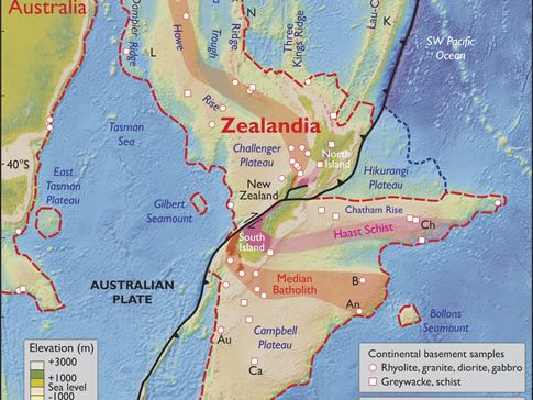
The lost continent, which is mostly submerged with all of New Zealand, is about half the size of Australia. By drilling deep into its upper layer, the new scientific expedition could provide clues about how the diving of one of Earth’s plates beneath another, a process called subduction. The new expedition could also reveal how that Earth-altering event changed ocean currents and the climate.
Expedition co-chief scientist Gerald Dickens, professor of Earth, environmental and planetary science at Rice University, said in a statement. “This expedition will answer a lot of questions about Zealandia.”
The drill ship JOIDES Resolution leaves Townsville on Friday for a two-month research voyage with up to 55 scientists on board. Professor Neville Exon of ANU Research School of Earth Scientists also agreed that this expedition would help scientists understand the “global tectonic configuration that started about 53 million years ago”.
“Zealandia, including today’s Lord Howe Rise, was largely part of Australia until 75 million years ago, when it started to break away and move to the north-east. That movement halted 53 million years ago,” he added.
Zealandia was named by US geophysicist Bruce Luyendyk in 1995 and was not considered continent material until February last year when a team of international scientists declared satellite technology and gravity maps of the sea floor had shown Zealandia was a large, unified area to qualify as a continent.


