
Hundreds of quakes were detected on the regional networks of seismometers and several were strong enough to be felt in Reykjavik, 50 kilometres away.
A civil protection alert was called warning of the risk of an eruption – which would be the fourth since 2021. Why is this happening again, and what might happen next?
Iceland straddles the Mid-Atlantic Ridge where the North American and Eurasian plates creep apart at about 2cm a year. In the Earth’s mantle below ground, where rocks behave like very stiff toffee, the plates can extend continuously.
But near the surface the rocks of Earth’s crust are cold and brittle, and they can only stretch by breaking. Like pulling the ends of a chocolate bar with a soft interior but a hard shell, the build-up of strain as the plates pull apart is released in bursts as the coating breaks.
The Reykjanes peninsula forms the south-western tip of Iceland, where the mid-Atlantic rift rises out of the sea. Here, the crust responds to inexorable tectonic forces by breaking every few hundred years, forming a rift.
The last sequence of rifting and eruptions here was over 800 years ago. Since then, the plates should have moved apart by about 16 metres.
We are now in another phase of rifting marked by hundreds to thousands of earthquakes, many large enough to be felt across south-western Iceland and all driven by the arrival of magma near the surface.
Each earthquake and eruption releases a bit more pent-up motion in these tectonic plates, and eventually, when that strain has been released, the eruptions will stop. We have seen similar bursts of rifting and eruption a couple of times in the past 50 years around the world.
History of Earthquakes in Iceland
From 1975 to 1984, 18 earthquake swarms and nine lava eruptions struck northern Iceland during the Krafla fires. Between 2005 and 2010, 14 earthquake swarms and three eruptions occurred along an 80km section of a rift valley in Afar, northern Ethiopia.
As at all oceanic ridges, the rifting process is lubricated by magma. Magma is forming continuously at depth, and its buoyancy means that it is destined to rise.
In the brittle crust, the magma can only rise once there are some fractures to follow. But once it starts to rise, it will force its way to shallower and shallower depths, increasing the risk of eruptions.
The scientists of the Icelandic Meteorological Office can detect what is happening at depth and locate the tiniest of shakes using networks of seismometers. These alert the team to the fresh breaking of rock in the crust and pinpoint where it is happening.
Sensors communicating with constellations of navigation satellites can provide spot measurements of the tiny movements of the Earth’s surface and radar satellite images can be used to map out and measure the three-dimensional shape of the changing surface.
The earthquake swarm that began in late October is the latest in a sequence of events that started in early 2020, and which has so far culminated in three eruptions at the Fagradalsfjall volcanic system in south-west Iceland in 2021, 2022 and most recently, summer 2023.
What’s Happening in Iceland now?
When the earthquakes began this time, they clustered around and under another volcanic system – Thorbjörn, 10 kilometres west of Fagradalsfjall. To start with, there was no visible deformation of the Earth’s surface and it wasn’t clear whether this was just a bit of the crust readjusting to the previous episode of rifting.
But once the signals showed that the Earth’s surface was starting to bulge, this indicated new magma was coming into the crust. Over the past weekend, things developed rapidly. The size, number and locations of earthquakes all pointed to the filling of a fracture in the crust with magma at about 5km depth.
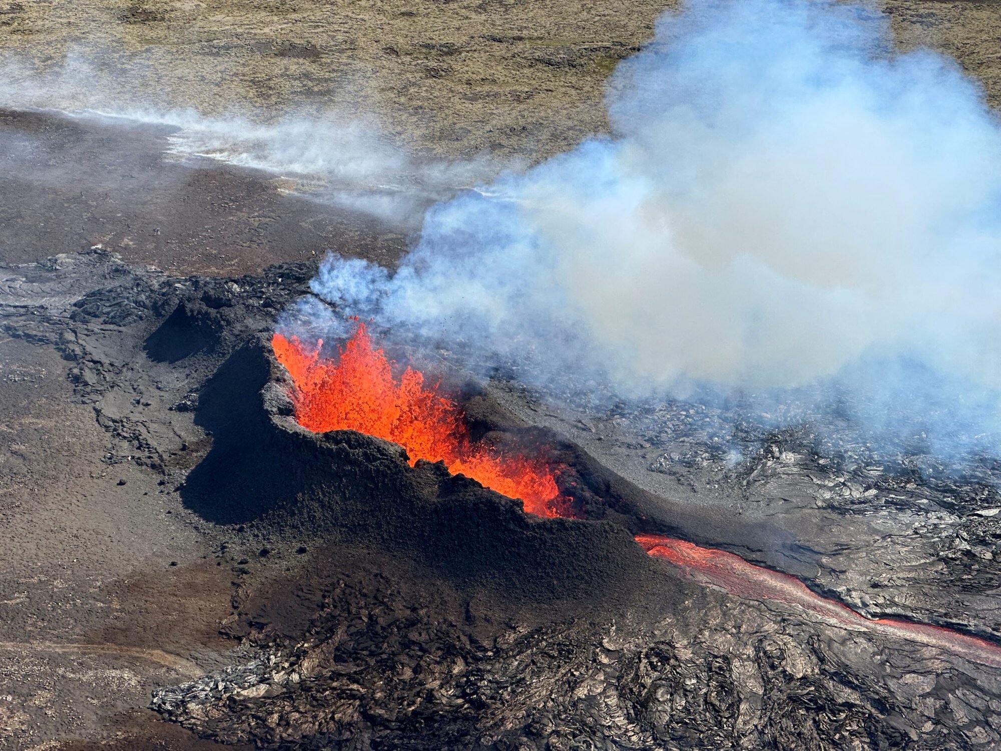
As the magma continued to flow into it, the tips of the fracture opened up, breaking a path through the crust until the new dike was about 15km long. The magma hasn’t yet reached the surface, but the patterns of ground movement and computer models suggest that a pool of magma has now collected within a kilometre of the surface.
At the time of writing, it seems quite likely that this magma will break through to the surface and start an eruption. But the monitoring teams will only know when and where this is about to happen once they spot the tell-tale signs of moving magma. These signs could include the repetitive “hum” of a volcanic tremor, signalling that magma may erupt within hours, or earthquakes proliferating at very shallow depths.
For now, the dike appears to extend directly underneath the town of Grindavik, a fishing community near Iceland’s south-western tip. If there is an eruption onto the land surface, it is likely to be similar to the eruptions of 2021–2023 at Fagradalsfjall, with a crack or fissure opening at the Earth’s surface and fountains of red hot molten rock, with lava flowing downhill and away from the eruption site.
This will pose a threat depending on where the eruption starts and how far the lava flows. Gas fumes released from erupting magma combined with the burning of peat and vegetation could create toxic air depending on eruption rates and wind directions.
If an eruption begins within the town of Grindavik, the effects could be similar to those of the eruption of Eldfell which buried a part of the town of Heimaey in 1973. Hence the pre-emptive evacuation of the town, of the nearby Svartsengi geothermal power station and the Blue Lagoon, one of Iceland’s best-known tourist attractions.
If an eruption starts at the southern end of the dike which extends offshore, hot lava meeting seawater in a submarine eruption could generate small-scale explosions and local ash clouds, and release further noxious gases from the boiling sea water.
While this probably wouldn’t have effects as widespread as those of the 2010 Eyjafjallajökull eruption, which closed the air space over a wide area of northern Europe for several weeks, even a small submarine eruption would add to the challenges that the authorities must manage even in a well-prepared country like Iceland.