

“People are urged to take extra precautions and stay up to date with the latest forecasts in case any changes are made to the current warnings and watches or further areas are added,” MetService says.
MetService is warning that the combination of snow and strong cold southwest winds from Sunday evening through Tuesday is likely to cause stress to livestock in parts of the lower South Island where a heavy snow watch is in force.
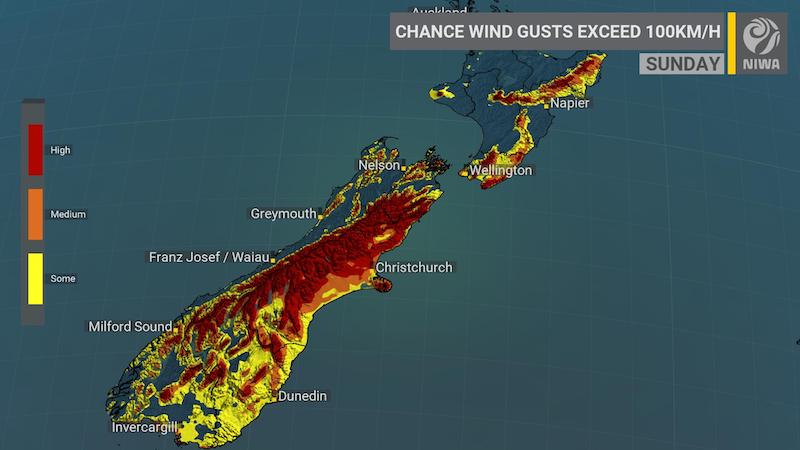
Travel disruptions are also likely as the snow and winds may affect many higher roads and passes across the South Island. Severe gales forecast for many places could make driving hazardous, especially for high-sided vehicles and bicycles.
Phew! Severe Weather Warnings and Watches issued-and there are heeaaaps of them! #SeptemberStorm is very unusual in how widespread the severe weather will be, make sure you are prepared by going to https://t.co/Yjbq0jxdqz. Snow comes later, additional warnings likely tomorrow ^TA pic.twitter.com/XtPpS7QfHW
— MetService (@MetService) September 24, 2020
“On Saturday and Sunday, there is high confidence of rainfall accumulations reaching warning amounts, and north to northwesterly winds becoming severe in Fiordland, southern Westland and the Canterbury and Otago headwaters, while northern Westland, Buller, Nelson and the Marlborough Sounds, including the Richmond Range have moderate confidence for both wind and rain,” MetService says.
“In the east of the South Island, there is high confidence of severe gale northwesterlies for the remainder of Marlborough and Canterbury on Saturday and Sunday, low confidence for Central Otago, North Otago and Dunedin on Sunday, and moderate confidence for Southland and Clutha on Sunday.”
#SeptemberStorm – See how the low pressure that shoots across the Tasman deepens rapidly, and the gales (yellow arrows) increase. The rapid deepening is due to strong support in the upper atmosphere including the exit of a jet stream. It will be windy! https://t.co/qHyE5zhh6X ^TA pic.twitter.com/thFJ2A9tmW
— MetService (@MetService) September 24, 2020
MetService added: “Meanwhile, across the North Island, on Sunday there is low confidence of warning amounts of rain for Taranaki, the King Country, the Central Plateau, the eastern Bay of Plenty Ranges and the Tararua Range.
“In addition, later Saturday and on Sunday, there is high confidence of severe gale northwesterlies affecting south Taranaki across to Wairarapa and down to Wellington, with moderate confidence for the remainder of the North Island as depicted on the chart.”
Stay up to date with the latest weather warnings here.
#SeptemberStorm – unusually widespread hazards
Widespread Severe Weather forecast with deep low and front this weekend and Monday. Chart compares pressure difference-an indicator of severe gales-with impacts from previous years. Warnings issued soon https://t.co/qHyE5zhh6X ^TA pic.twitter.com/VpPhdco5H7
— MetService (@MetService) September 24, 2020